
Knocklayd
Original Data: D 11517 36392 Height: 515.7
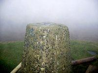
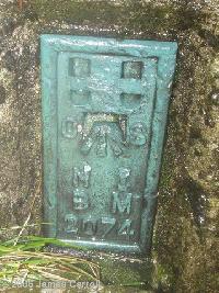
| 2007-07-17 Bridgeman reported: D 115 364 | Elev:514
| FB:OSNI 2074 | Pillar:Good | View:Good
Walked out from Ballycastle armed with the old OSNI 1;50,000 First Series map. I attempted to follow the old route of the Moyle Way over Knocklayd. Where it leaves the main tyrack in Ballycastle Forest I did manage to find a forest break but it proved difficult as I neared the edge of the forest. The lower slopes of the ascent were very wet under foot but I reached a fence to gain the summit. I decided to stay with the Moyle Way for the descent and continued on a faint path down the drier southern side which was much easier. Only one fence had to be crossed to reach the lane at D119345 close to a deserted farm. There is a sign saying 'Private Land' here but this appraoch to the summit is by far the easiest. My return to Ballycastle was via the Moyle Way to near Coskemnacally, glenbank house and the attractive Glenshesk on a very quiet lane with good views. |
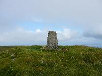
| 2006-11-07 JC reported: D 11522 36395 | Elev:520
| FB:OSNI 2074 | Pillar:Good | View:Excellent
99m away from reported data. I would never have found it in the very bad visibility (20m), had I not made my own estimate from OS map when planning the trip. |