
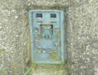
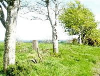
Drumhirk
Original Data: J 4605 657 Height: 75m
| 2009-05-17 spandrel reported: J 46053 65701 | Elev:61
| FB:OSNIBM3024 | Pillar:Good | View:Good
On top of a small hill almost on an old field boundary made up of widely spaced weather beaten trees. Access to the start of the field boundary was via an over grown farm track to the east of the trig point. The view is good to the east is a sweeping vista taking in Scrabo Tower to the north almost all of Strangford Lough & finishing with Slieve Donnard in the South. |