Login
Grid Ref. Search Detail Map About ... Home
User Area Register Links Gallery

Definitions and Information

What is a Trig Point?

How is a Trig Pillar Made?

What is Trigpointing?

What is a Bench Mark?

About Trigpointing Ireland

The Retriangulation of Northern Ireland.

After OSNI was set up in 1921, OSGB retained responsibility for the geodetic triangulation. The second World War delayed the re-triangulation of Great Britain, but when it was completet, resources were made available to OSNI and observations on the re-triangulation began in the spring of 1952.

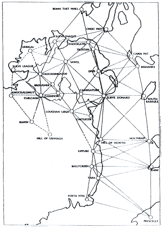
The network consisted of nine stations plus three in the Repiblic of Ireland and a number of cross-channel connections to GB. The adjustment accepted the position of three of the original Principal Triangulation points in order to scale and orientate the new triangulation. These points were Divis, Knocklayd and Trostan. Comparisons to the (then) recent re-triangulation of GB showed only a slight discrepancy between the two re-triangulations.

Ordnance Survey
in Ireland

1824 Ordnance Survey Ireland (OSi) established. Major survey by Thomas F. Colby begun.
The History of Ordnance Survey
1827
to
1828

The Lough Foyle Base Line
1839
to
1843
The first levelling of Ireland.
Poolbeg Datum
1846Colby's survey was completed.
1867A more comprehensive survey was completed.
1921Ordnance Survey N.I. set up
1952Northern Ireland Retriangulation
1957A new vertical datum for NI.
Belfast Datum
A combined datum for OSi and OSNI was also established at Malin Head.
1959Republic of Ireland Retriangulation
1970The work of adjusting the observations from the Republic of Ireland and from Northern Ireland to form one entire network related to MSL Mailn was completed.
Malin Head Datum